With sea levels rising, there is cause for concern about the livability of major coastal cities—often huge centers of trade and commerce, and homes to millions of people.
But an overlooked area is how coastal cities are themselves sinking—a phenomenon called relative local land subsidence (RLLS)—which occurs when underground materials, such as soil, rock, or even man-made structures, compact or collapse, causing the surface above to sink.
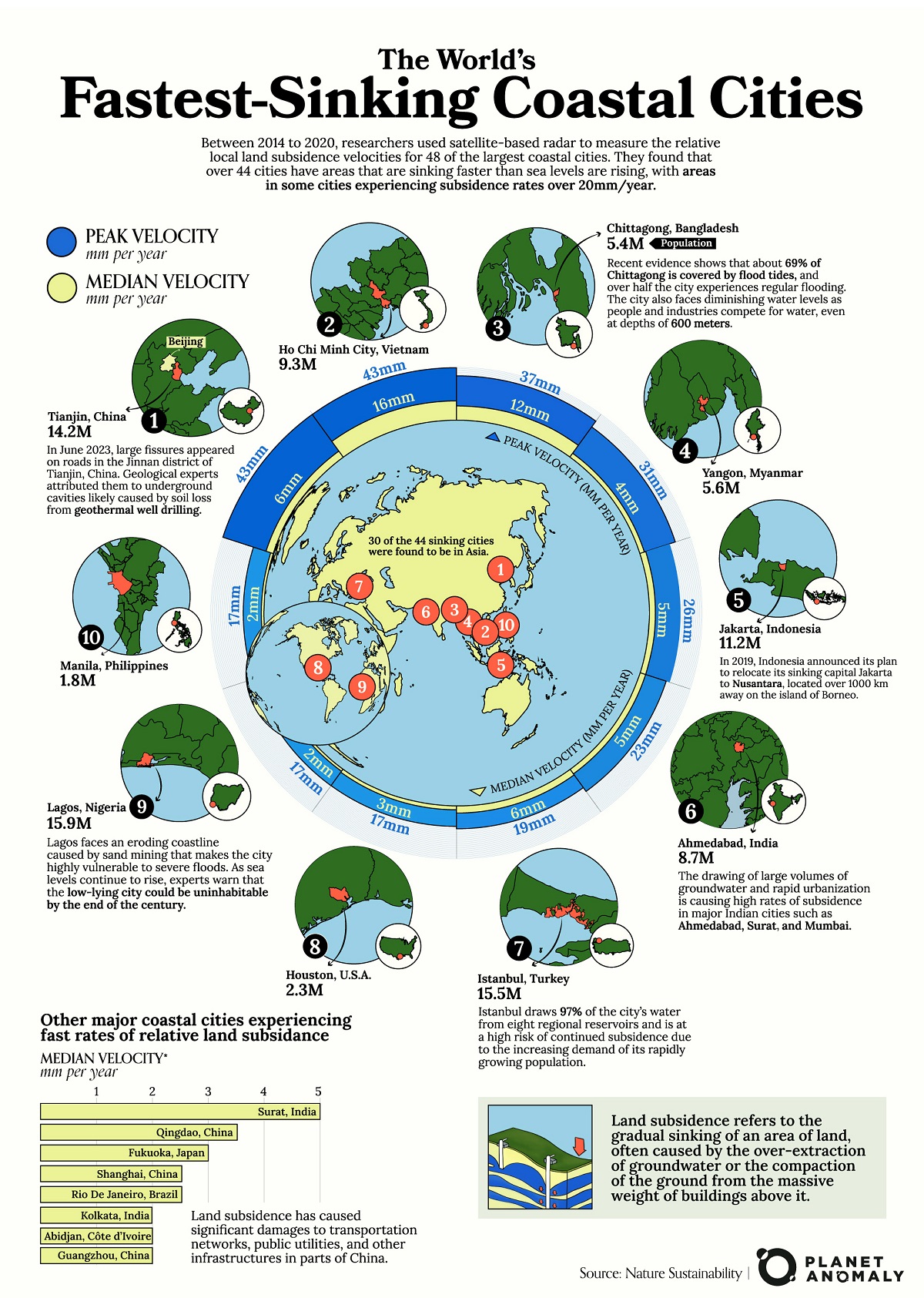
This can exacerbate the effects of rising sea levels (currently averaged at 3.7 mm/year), and is a useful metric to track for coastal communities.
Creator Planet Anomaly, looks at the top 10 cities ranked by the peak subsidence velocity. This graphic is based on a paper published by Nature Sustainability, which used satellite data to track land subsidence changes in 48 high-population coastal cities located within 50 kilometers of the coastline. Their data collection spanned six years from 2014 to 2020.
?? Interferometric synthetic aperture radar (InSAR) utilizes two images taken at different times, which are then compared to create an interferogram. This interferogram illustrates changes in land motion relative to a reference point in the satellite’s line-of-sight over time. By analyzing a series of these interferograms, researchers can estimate the long-term velocity of the ground’s surface for each city.In that time period, they found that 44 of the cities they studied—many of them massively populated, developed megacities, built on flat, low-lying river deltas—had areas sinking faster than sea levels were rising.
The 10 Fastest Sinking Coastal Cities
One of the top cities on the list is Tianjin, China with a population of more than 14 million people, which has areas of the city experiencing peak RLLS velocities of 43 mm a year between 2014–2020. The median velocity is much lower, at 6 mm/year, which means some areas are sinking much faster than the overall metropolitan area.
Tianjin is bordered by Beijing municipality to the northwest and the Bohai Gulf to the east. In June 2023, large cracks appeared on Tianjin’s streets, caused by underground land collapses, a byproduct of extensive geothermal drilling, according to the local government.
Rank City Country Peak Velocity
(mm/year)Median Velocity
(mm/year)1 Tianjin ?? China 43 6 2 Ho Chi Minh City ?? Vietnam 43 16 3 Chittagong ?? Bangladesh 37 12 4 Yangon ?? Myanmar 31 4 5 Jakarta ?? Indonesia 26 5 6 Ahmedabad ?? India 23 5 7 Istanbul ?? Turkey 19 6 8 Houston ?? U.S. 17 3 9 Lagos ?? Nigeria 17 2 10 Manila ?? Philippines 17 2 Ho Chi Minh City (population 9 million) in Vietnam also faces similar RLLS rates as Tianjin though its median velocity is much higher at 16 mm/year.
Chittagong, Bangladesh, Yangon, Myanmar, and Jakarta, Indonesia, round out the top five fastest sinking coastal cities by relative land subsidence. They all face a similar web of contributing factors as the authors of the paper note below:
“Many of these fast-subsiding coastal cities are rapidly expanding megacities, where anthropogenic factors, such as high demands for groundwater extraction and loading from densely constructed building structures, contribute to local land subsidence.” — Tay, C., Lindsey, E.O., Chin, S.T. et al.
In fact, Indonesia has ambitious plans to relocate its sinking capital, Jakarta, to another island, a move that could cost the Indonesian government more than $120 billion. This comes after the forecast that one-third of Jakarta could be submerged as early as 2050. Aside from the regular flooding, Jakarta is also extremely prone to earthquakes.
Why Measure Local Land Subsidence?
The researchers of this report argue that local land subsidence is largely underestimated in relative sea level rise assessments and is crucial for the sustainable development of coastal areas.
The data they’ve collected—peak velocity versus median velocity—also allows them to identify specific areas and neighborhoods in cities that are undergoing rapid subsidence and thus facing a greater exposure to coastal hazards.
In New York, for example, their results suggested that subsidence is only localized west of Breezy Point and “should not be extrapolated eastward along the coast” of Long Island.